In Praise of Place: Valley of Dreams, New Mexico
I probably stopped posting to this site at more or less the same time I started looking for Valley of Dreams. (In the meantime, I’ve been posting images unadorned with accompanying text to my 500.px portfolio.) I’m not implying that my success in finding this far-flung hoodoo outpost has anything to do with my resumption of writing about photography—I’m just noting the coincidence. The fact that I finally found my way to VOD simply makes for a good excuse to start up my personal photography blog again. Because I think VOD is worth talking about, for several reasons.

Alien Throne
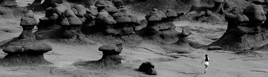
A quick g-search will lead you to the kinds of things I’ve been reading online about VOD for years now. And a g-image search will bring up a dozen-ish pictures of a particular feature dubbed the Alien Throne, a genuinely creepy looking hoodoo that might have been designed by H.R. Giger, were he in the business of designing hoodoos. But the Throne is only one of literally hundreds of fascinating rock formations carved by time and differential erosion out of the layers of late Cretaceous mudstone and sandstone here. (And is that a coal seam we see in the rock layers? Or dark-colored shale? Further study of the geology of the region is indicated.)

Turn left here. Walk toward the yellow butte. No, not the first one…
This is not intended to be a guide to finding your way to the Valley of Dreams. If you’re interested in visiting it in person, I refer you to the numerous posts which attempt to lead you there, one dirt road turnoff at a time. (Good luck with that approach, by the way. It didn’t work very well for me, perhaps due in part to the fact that a couple of the most detailed trip accounts had to be translated from their original German.) The breakthrough came by my having figured out how to use g-maps in offline navigation mode. Using coordinates from one of the more recent online trip accounts (I’m not saying which one), navigation led me right to the turnoff on a dirt road that was more of a suggestion of a two-track than an actual path for vehicles.
Imagine my surprise, then, when—having bounced and high-sided for a mile or so down this tenuous track—I saw another sport utility like mine cutting at a crosswise angle in front of me. It passed on to my right as I continued directly down toward the flat, cleared “parking area” mentioned in the directions I was attempting to follow.
Thrilled to have actually made it this far, I commenced applying sunscreen and making preparations to don my backpack. I could see the distant yellowish hill denoting the location of the VOD off to the west. (At least, I thought that was the hill in question—it turned out not to be, but more about that later.) That’s when the other SUV topped the rise behind me and pulled up next to my trusty, dusty 2013 Rogue.

There’s a lot going on here
“So this is the place, eh?” commented the driver, after rolling down his window.
“It is if you’re looking for the Valley of Dreams,” I said.
“Oh, so we’re not at Ah Shi Sle Pah?”
I explained that some people consider VOD to be an extension of Ah Shi Sle Pah, but it’s actually outside the wilderness study area boundary and several miles off to the NW. Once it was clear that the same kind of scenery would be involved, however, the matter was settled.

Thanks, differential erosion!
Joe and Liam had traveled from Michigan and were borrowing Joe’s Santa Fe-based sister’s sport ute to tour around the countryside. They were camping at Chaco for a couple of nights and had read about the formations hereabouts. We quickly agreed to team up and hike as a group toward the VOD. Personally, I was pleased to have the company. Regardless of how terrain-savvy and well-prepared you might be, having companions on a wilderness excursion is always the best approach. Things can go wrong—ankles can get twisted—route finding can go awry, and two or more level heads are generally better than one when it comes to finding your way back to the safety and shelter of your vehicle.
And whether you call it the luck of the draw or divine providence, Joe and Liam turned out to be amiable and worthwhile hiking companions. Which always helps.

A large-ish hoodoo. One of hundreds hereabouts.
We headed north along the diminishing track of the road until it crossed a prominent gully, at which point we were prepared to hook a left and go west toward the aforementioned yellowish hill. The sandy, silty terrain supported little in the way of vegetation, as is typical for the region. We did encounter a large quantity of cow patties, however, leading one to wonder how cattle could make a go of it in such inhospitable conditions.
Upon reaching the yellow hill (and climbing it to get a look around), we found no network of toadstool hoodoos or any other indication of where the formations might be. A serious disappointment, and a seeming failure of the directions that had up to now been right on the money. But after scanning the horizon farther to the west, Joe spotted what he thought might be some broken terrain with promise. While it appeared to be much farther away than I was expecting, we decided to head in that direction. Which turned out to be the right call.

Lurker at the threshold
Distances are remarkably deceiving in this country, and such was certainly the case here. As we trudged up and down gullies in a bee-line toward the distant hills, we seemed to be getting there a lot faster than we should have. We could soon make out distinct hoodoo shapes skirting the rise before us. (As noted in one of the more recent postings I googled, the Valley of Dreams should more appropriately be called the Hill or Ridge of Dreams, given that its prominences rise above the surrounding terrain.)
While it would be easy to let these images speak for themselves, here are a few big picture items of note: The ridge of rock formations is roughly oval in shape, extending east to west on the long axis for maybe half a mile. There are so many side draws and prominences that exploring the area thoroughly would take a full day and a lot of up-and-down scrambling. I made a wide, leisurely clockwise loop around the plateau and continued to marvel at the eccentric and extravagant shapes of the formations. The color palette here is primarily yellow/buff, with patches of ironstone red and a good deal of dark gray to black, particularly on the western edge of the outcrop.

Prayerful maiden
Not long after locating and marveling at the Alien Throne, we decided by mutual agreement that it was time to head back to the cars. It had been a hike of roughly 1.5 miles to the VOD itself, and probably a mile’s worth of wandering around, up and over after we arrived there. So I’m guessing we put in a good 4+ miles of walking by the time our midday exploration was done. While the weather was balmy and the skies blessed us with clouds to improve our photography, the ever-present spring wind was kicking up, gusting around corners and frequently threatening to rip the hats off our heads.
Camping is not recommended here, because the question of surrounding private land boundaries comes into play. The thought of having a landowner close off access to this wonderland of rock monuments due to abuse of privilege is too much to bear. Let’s be smart and respectful and keep the dirt track approaches open for those who make the long trip out here.

Dark shale or coal seam? I think there’s some of both around here.

Thank goodness for the clouds

Blockhead

Easy button

Not the Alien Throne

Alien Throne

French baker at his oven, perhaps?

Squished eyeball and optic nerve

Until next time, VOD
Beware the Woods
My great grandfather, Orlando Redondo, pioneered these blackland prairies in the mid-1800s. From the earliest days of his cultivation of the acreage purchased with gold from his native Brazil–gold whose origins remain a subject of historical concern for high-minded whiners with nothing more productive to do with their time–there was one plot of land that he chose to keep in its unaltered state. It was upon the thorns of an evil-looking tree on the edge of this still-pristine semi-wilderness that I discovered the note I transcribe for you here.
With resources a scant fraction of those accessible to my notorious ancestor, I live in a modest house in a rather undistinguished subdivision carved out of the remnants of old Orlando’s rambling rancho. The urban wildland in question lies but several minutes’ walk from my front door, so I visit the pocket forest frequently on my perambulations around the neighborhood. Though, after today, I shall never again venture into its shadowy interior.
The note itself I can no longer offer as evidence, because it simply faded from existence not long after I finished reading it. Fortunately, I copied down its contents even as the wild cursive scrawls began to shimmer and grow faint before my eyes. This old photograph, for whatever reason, has remained intact and appears to have been taken sometime in the middle years of the 20th century, judging by its yellowed surface and certain other visual clues.
The pathway depicted remains more or less the same as it did when this image was captured, and will be immediately recognizable to habitués of the city park that encompasses the woodland. I think you can understand why: Even to the unimaginative eye, it appears to be a portal into a darker and perhaps more insubstantial realm.
The phantom letter reads thus:
“I write to you now from a place beyond reach or understanding. I have no way of knowing whether this message will be found by anyone on the other side–the daylight side–or whether, in fact, they will be able to read or make sense of it if it is discovered.
“I know not why I have been consigned to this living Hell–this purgatory of endless shadow and ever-shifing boundaries. I only know that, for me, there appears to be no escape. I can only hope that what you read here may serve as a warning against following the path that I chose to follow on the night of All Hallows’ Eve.
“Although… the thought of having another living soul here to share the miseries of this nightmare realm holds a certain perverse appeal. (Did I say living? In all honesty, that seems more and more unlikely.)
“It all began with a solitary walk into the park on the aforementioned occasion. The day was nearing its finish–I chose the hour of declining light due to its relative calm and in appreciation for the quietude brought on by the end of the workday hustle and bustle.
“Even before I left the mundane streets and sidewalks of my quiet suburban neighborhood, there were signs that something was oddly amiss. I simply chose not to pay them much attention, and for that I have paid a terrible price.

“A stately oak growing from the verge between a neighbor’s sidewalk and the street appeared to have suddenly burst its boundaries, spilling out over the surrounding concrete as if it were composed of malleable putty rather than solid wood. As I walked past it, I tried to recall whether its roots had recently taken this invasive form or whether I had simply not noticed them before. Did I sense a slight vibration as I walked past it on the sidewalk? If so, I wrote it up to unsure footing–perhaps I had slipped on an acorn hidden beneath the leafy detritus.
“Far more unsettling was the appearance of the two early trick-or-treaters I encountered just before entering the parkland. They exhibited a startling lack of animation, and their masks seemed strangely… organic, I suppose is the best way to describe it. I walked on without greeting them in any way, and they likewise paid me no mind.

“Upon reaching the path that would carry me into the deepest part of the woods, I approached a huge, globular-shaped bush whose aspect seemed indefinably ominous, though I cannot say exactly why. As I walked past, a gust of wind stirred the leafy branches and made it seem that the foliage was being shaken from within. I could swear I heard a faint murmuring, as if from a troubled elderly gentleman, emanating from its leafy depths.

“I hurried past and entered the forest proper, whereupon the entire atmosphere seemed to change. A stillness and quietude settled over all, as if–having crossed some invisible boundary–I had entered an entirely alien realm. Which, of course, I had, though I didn’t become fully aware of it until a good bit later.

“It struck me as odd that, here on a presumably oft-visited path through a decidedly urban parkland, the floor of the forest was littered with undisturbed leaves; should they not have been swept clear by the passage of countless city-dwellers such as myself? Surely I was not the only soul to have entered these woods since the trees had given up their desiccated burdens.
“The path forked periodically as it wound its way between oaks, willows, sycamores and hackberries of all ages and in various conditions of health. But still I heard not a whisper of birdlife or even a hint of wind. It seemed as if time had ceased to pass here in these dank and colorless woods. I wandered on–and on yet further. I’ll admit by this time I had begun to wonder whether I had, indeed, taken a wrong turn, or perhaps several, as I tried to reason how it could be possible that I had not yet emerged from this modest stand of woods.

“It was at this point that panic overtook my better judgment and I began to jog rather than amble through this preposterously expansive forest. I felt that if I picked up my pace I might somehow burst through the confines of the encompassing branches and enter the daylight once again–or the dusk, given that the hour was much advanced from the late afternoon timing of my arrival.
“It was during this headlong flight that I stumbled foolishly into the spines of a briar. The pain of a dozen puncture wounds served only to increase my panic, which must have hastened the effect of the poisonous sap injected by the evil bush. I swooned, my head reeled and the ground rose up to meet me with a stunning blow.

“How long I remained unconscious I cannot say, though judging by my parched throat and rumbling belly it might very well have been days. Nevertheless, when I came back to my senses the condition of the woods had not changed–which is to say that gloom and utter silence still held general sway. I stumbled further along an indeterminate path and soon found myself in a misty clearing, still surrounded by woods but at least able to peer upward into a sky shredded by streamers of clouds. Here, finally, was some movement to put to rest the lie that the world around me had frozen for all time.

“A tree in the midst of this clearing bore an astonishing bounty of perfectly ripe fruit. It looked delicious, at least to my addled mind and empty stomach. Not apples, because too large; not pears, because too round. Each gray, glistening globe seemed to call out to me with the promise of quenching moisture and enriching sustenance. Of course I bit into one–how could I not?
“It was only after consuming the second of these curious-tasting fruits that I found myself floating back toward the depths of the forest. Being a man of reason, I presumed I was experiencing a hallucinogenic effect–though this knowledge did nothing to lessen the outre nature of the experience. At first, the visions proved awe-inducing and delightful. I seemed to commune with the very essence of the trees and found myself becoming like a tree in order to know them better.

“It was all very exciting–until I came to the realization that I was not alone.

“In amongst the bare branches of a dying grove of red cedar I perceived a ghostly figure, staring straight at me. When I first brought him into focus, the shock of the encounter found me frozen to the spot–I literally could not move for what seemed like several minutes, though the time elapsed was probably closer to a score of seconds.
“Breaking out of my fear-induced inaction, I moved marginally to the left–and the shadowy figure (taking on more substance as I looked on in mounting horror) mirrored my motion. I moved to the right–with the same reflective result from the expressionless phantom. I turned and ran without thought of any destination or consequences, with the astonishing result that I passed right through a thick-limbed tree without any discernible resistance.
“I imagine you’ve come to the same conclusion that I did at this point–which is that I myself had become a phantom, imprisoned in this shadowed realm out of space and time. I attach this note to the brambles of the very briar that impaled me in the hope that someone will find it and know what to do to execute a rescue operation. Failing that, I trust that this message, if found, will serve as a warning to those who would enter these unhallowed woods on All Hallows’ Eve.

“It’s all I can do from where I now stand.”
In Praise of Place: Lybrook Badlands, Part 2
 The terrain to the south, as I discover during my afternoon hike, is equally weird and wonderful. After traversing a cracked dirt mound that takes me beyond the bowl-like confines of camp and into the neighboring dry wash, I enjoy the open view to the east where a series of step-like benches culminate eventually at the overlook I visited a couple of years ago – and from which, frustratingly, I could find no feasible means of descent into this fairyland of erosional features.
South and east stretches a rim of peaks characterized by their corrugated flanks, varied coloration and low-level hoodoo battlements. Towering above a cadre of molar-like hoodoos is a most improbable cone of banded clay that rises precipitously to a point, as if recently attended by that great pencil sharpener in the sky. I’m struck by a visceral, lizard-brained urge to climb it, or at least climb up to the base of it to better grasp its significance and somehow absorb its radiating other-worldliness. But I resist.

To a point

The great cone

Around the bend

Tumbledown

Battlements

The littlest hoodoo

Yucca view

Gnarled
I return to camp in time to relax with a beer and a good cigar before preparing for my evening walk up into the same terrain I visited this morning. I pack along a longer focal length zoom lens (though the trusty 16-35 never leaves the camera body, as it turns out), plus gorp for emergency energy and water – because, duh, water! I also don an LED headlamp in case I tarry too long up above and need help finding my way back down to camp.
(In fact, the route back down is problematic, even in daylight. Being a natural-born worrier, I struggle with the idea of working my way back up into the broken country this close to sundown, with the specter of a cold overnight bivouac—or, worse, a head-first tumble down a precipitous clay slope—front of mind.) As I’ve done on prior such solo expeditions, I overestimate the rapidity with which darkness can fall and spend a couple of hours waiting for it once I’ve returned safely to camp.

Shadow of a cigar

Run away, sun

Flat as a pancake

In between

Breaking ranks

Abandon hope

Point of interest

The tail

Crack in the earth

Twilight in the garden of moral ambiguity
The air mattress I inflated earlier provides adequate cushion against the dusty ground for most of the night, and although I have my usual difficulty sleeping soundly (we’ll not go into the tribulations of advancing age and its attendant complaints) I don’t seem to mind it much. The privilege of simply being here makes up for any short-term lack of creature comforts.
During my 24 hours on site, the number of other visitors I encounter in the Lybrook badlands remains at a smirk-inducing zero. In fact, the last person I saw before turning off on this final spur road, and the first person I see again upon leaving it, is the driver of an oil tanker truck, who waves at me appreciatively as I pull to the side of the narrow track and allow him to pass.

Broken
No other visitors? That’s just the way I like it. As for you, I suggest you check out the far more well-known and routinely-visited BIsti/De Na Zin wilderness not far to the northwest. You’ll much prefer it. Trust me.
In Praise of Place: Lybrook Badlands, Part 1
 Tucked away in an obscure corner of northwestern New Mexico lies a land of eroded stone-and-clay structures that seem inspired by the visions of Giger and sculpted by the unsteady hand of a gibbering lunatic. (God? Mother Nature? Choose your favorite causal metaphor and/or deity.) I’ve packed along the proper supplies and gear for spending a night out here in the vasty wastes, because—as all photographers know—the best light occurs in close proximity to sunup and sundown.
(It’s a testament to my enthusiasm for image-gathering that I take this camping-oriented approach, having reached an age and a level of self-realization that makes me aware of a distinct preference for comfy bedding and interior climate controls. But the truth of the matter is that the badlands region in question is remote enough from any such accommodations that the feasibility of being there for golden light dictates sleeping on the hard ground, in the questionable security of a tent.)

Colorful cacti
I’ve spent several years (and three previous trips to NW NM) planning and researching for this. Lybrook, I’ve concluded, is the least-visited of the region’s badland precincts for a number of regions: as mentioned, it’s remote from tourist accommodations; it’s probably the last of the major badlands areas to be documented in terms of access; and the dirt road approach requires something more robust and lofty than the family sedan, primarily due to a couple of dished-out low water crossings with treacherous sandy footing. Your Honda Accord won’t be making the trip, at least not all the way – though your (or my) Nissan Rogue should encounter no difficulties, if driven with care.

Morning moon
(Wait – I’ve almost forgotten to mention that all bets are off if you happen to be driving on this stretch of road in the rain. Prepare to be stuck. Hope you brought along plenty of drinking water and a deck of cards for some real-life desert solitaire.)

Watchtowers
Which reminds me – I won’t be sharing any details of the route with you here. I did my homework and studied up on the several available descriptions of road junctions, turnoffs and mileages—some of which will take you to the heartland of hoodoos and some of which won’t—so why shouldn’t you do the same? I think you’ll benefit from the Googling exercise, and it will make your successful excursion into the Lybrook all the more satisfying.

Silent witness
(Plus, I’d prefer you simply stay away. Nothing spoils a special place like the tromping of too many boots.)

Rock and clay
Suffice it to say that we owe our drive-up access to the road-building engineers of the oil and gas industry, who have so kindly provided us with an easy way into the nexus of the backcountry. Salute or Bronx cheer, as you see fit.

Primrose POV
Due to a brain abnormality that stems from the fact that I grew up Texan in the era of Gunsmoke, Rawhide and Have Gun – Will Travel, I pack along a pistol – though not of the six-shooter variety. It’s a sub-compact 9mm, more or less the equivalent of a snub-nose .38 revolver. The utility of such an arm on a camping excursion is questionable at best. There are no wild animals out here that pose any sort of a threat that could be alleviated with such a handgun. Reflecting on the matter, I suppose it could be used to dispatch a coyote – but why would I want to shoot a coyote? I like coyotes. Their strident yipping on a lonely night spent on the fringes of civilization is music to my ears.

Plugs, caps and mounds
The thought of blasting the head off a vicious rattlesnake occurs as a possible justification for firearms carry, but my marksmanship with the diminutive automatic is such that I would need to expend a good deal of ammunition to have a chance at coming near such a target. Truth be told, I’d be far better off hurling a fist-sized stone, of which there are plenty on-site. (Besides, rattlesnakes are not vicious and are better off simply avoided.)

Rooftop planting
But enough about my mental aberrations. The fact remains that I feel better about arming myself when I venture off alone into the sticks. I comfort myself in the fact that the pistol can be used as a handy noisemaker in the event I become trapped without means of escape, 127 Hours-fashion. Strings of three shots are known to be taken as a sign of distress. (At least, they were in the era of Gunsmoke, Rawhide and Have Gun – Will Travel.)

Shroom
Arriving at my destination and parking at a reasonable distance from the oil pumper and attendant storage tanks, I bask in the glow of satisfaction at having reached this place. It’s midday, more or less, and cloudless—in other words, the worst possible conditions for photography—but that doesn’t stop me from tally-ho-ing my way onto the cracked dirt slopes, camera in hand (or on strap) and backpack packed with high-energy food items and water. My plan is to see as much of the surrounding territory as I can with the goal of scoping out a likely photographic perch to return to come sundown.

Tricorne
Before too long I’m reminded of how treacherous the footing is on these deceptively gentle slopes. Due to their varied clay/dirt/crushed stone composition, one quickly develops a sense of the risk factor involved with each kind of surface:

• Gray w/mud cracks – take care! Although your foot plant feels solid, shifting your weight may bring on a palsy-inducing shamble as you attempt to reach firmer ground.
• Reddish w/embedded irregular pebbles – warning: though the surface seems semi-firm, its underpinnings don’t know the meaning of stability. Make your way quickly and carefully to an area of gray w/mud cracks.
• Grayish-white w/embedded round pebbles – you idiot! How did you end up standing (if you are still standing) on this stuff? Immediately proceed (on your butt) to the nearest non-grayish-white w/embedded round pebbles surface and thank your lucky stars that you haven’t slid all the way back down to your starting point. Unless you have.

On solid ground
In the Lybrook there is one saving grace: a stratum of rock-solid calcite that forms a band just above the lowest erosional level and at the base of the mid-level hoodoo gardens. By floundering one’s way up to this ledge-like structure, a canny hiker can quickly traverse long stretches of terrain with only the occasional need for detouring onto less-substantial footing. It’s the only way to fly!

Defile
Even though it’s late May, midday and cloudless, a wind out of the north is keeping things cool enough that my jacket feels pretty good. I’m discovering a wonderland of rock formations with something curious, charming or spectacular around every bend. My camera’s shutter is getting a workout. It’s a good day to be alive and ambulatory.

Across the chasm
Having worn myself out sufficiently and gotten a good idea of the lay of the land to the north of camp, I retire for a bit and break out a book while enjoying a lunch of gorp, pemmican bar and apple. I position my lawn chair on the north side of the Rogue to eke out as much shade as I can. My trusty floppy hat certainly helps.

Bent

Globe

The fountain

The boot

Ice cream cones

Table rock

Debris field

The kiss

The top

Gunsight

Yellow Rose of New Mexico

Magenta
In praise of place: Ballroom Cave in Upper Butler Wash

Drooping tree, West Upper Butler Wash
Comb Ridge is bordered on the east by the long north-south trending drainage called Butler Wash. The east-facing rocky cliffs and dished-out overhangs along this mostly dry creekbed preserve a number of ancestral puebloan ruins and petroglyphs. A great deal of visitor attention is paid to the section of the wash between 163 (W of Bluff) and 95 (W of Blanding), probably because this part of the wash is paralleled by a rough dirt road.
North of 95, access to the section known as Upper Butler Wash (or West Upper Butler Wash, to differentiate it from the part that branches off to the right just north of the highway) is by trail. The path follows the alternately sandy and rocky creekbed, which is graced with shade along much of its length courtesy of the abundant cottonwoods and associated riparian flora – quite a boon during hot cloudless days.
A walk up the wash is like living an adventure story right out of the movies – around each bend awaits … who knows what, really? All one knows for sure is that several prominent Anasazi ruins await the hiker who knows where to veer off the trail and scramble up the water-worn rock slopes to the cliff faces above. It’s enough to make a person want to explore every side-canyon, regardless of his or her carefully planned itinerary.

Curious alcove – NOT Ballroom Cave, however
Specifics to be found on the internet vary, but approximately 1.7 miles up the wash from 95 is a clearly-marked (thanks, BLM!) divergence off to the left that climbs the rocky slope to Ballroom Cave. If you haven’t already spotted the ruins from the wash below, you’ll soon make them out as you approach up the steep path. This ruin is a classic example of something that looks modest from below turning into something downright spectacular upon arrival.

Defensive breastworks and/or observation post – Ballroom Cave
If there’s any question about the identity of the ruin in which you now stand, the government agency in charge has removed all doubt by providing the visitor with documentation stored in a handy waterproof ammo can stashed next to one of the two crumbling kivas to be found here. Within the printed pages are details of the timeframe during which the ruins were inhabited (1200 A.D., more or less) and reasoned speculations about the lifestyle and social organization of the builders and residents.
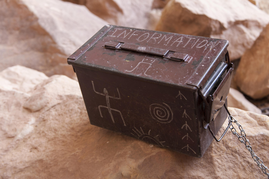
Thanks, BLM!
Evidence as to lifestyle includes numerous potsherds and a surprising abundance of ancient corncobs. There are also a large number of metates/grinding grooves in the boulders littering the overhang.

Grinding grooves
While the term “cave” is bandied about incautiously as applied to many southwestern ruin sites, here it is actually appropriate, as a vast cavern opens up downslope behind the observational and/or battlement masonry structure that today glares mutely out over the canyon below. There are said to be bats residing on the ceiling of the place, though a desultory appraisal did not reveal such to this explorer’s gaze.

Down to darkness
It should go without saying at this point that removal of relics from a site such as this is llegal, immoral and a sure sign of downright assholery on the part of those doing the thievery. Aside from the federal offense aspect, disturbance of cultural artifacts ruins the ruin, if you’ll excuse the expression, for purposes of archaeological study. More importantly from a casual visitor’s standpoint, the actual presence here of such physical reminders of the past makes the journey a true adventure – a veritable walk back in time.

Improbable preservation
Frankly, it’s somewhat astonishing that sites such as this that are entirely unsupervised still contain pocketable antiquities of any variety. It gives me some hope for man’s better nature, and makes me think that the educational process must be having some positive effect in terms of instilling a respect for the past and fostering a mindfulness to support sharing it with others.

Tri-color anthropomorphs, Ballroom Cave
(NAH. It’s probably just that not many people have found the place – and those few who make the effort have a certain amount of respect for the idea of historical preservation.)

The view below

Rock texture, Ballroom Cave

Masonry detail

Handprint, Ballroom Cave

Crack in the world

Disoriented – Ballroom Cave
On our return trip down the wash back toward the highway we paused to clamber up a steep drainage to take in the view of Target Ruin (aka Bullseye Ruin). This improbably-sited masonry and jacal “mixed-use” structure shows remarkable preservation – undoubtedly due to the fact that it is inaccessible. It perches a dozen feet or more above us on a ledge that appears unreachable with anything short of a fireman’s ladder. Even a rappel from above looks like a sketchy proposition, given the broad brow of the overhang. So in the case of Target Ruin, one must be content to marvel from below at the resourcefulness of the builders and inhabitants.

Target Ruin

“Mixed Use” facility? Target Ruin
(Are those Moki steps I see on the sandstone below the ruin? Or perhaps posthole anchors? Maybe just natural rock cavities that I’m “anthropomorphing” into something they’re not.)

Target Ruin, West Upper Butler Wash
Deep heritage: SW Colorado in late September

Kivas: restored vs. unrestored
For five years now, Anne and I have traveled to the Southwestern US to spend our annual week’s vacation. These trips have centered on the canyonlands country around Moab, Utah – but for the past several years I’ve made a point of choosing a different starting point, where we’ll have a day or two to see something we’ve never seen before and (potentially) find new places to love before driving on to our favorite hangouts in and around Moab.
This year, as usual, we started by flying into Grand Junction and renting a car. Then, instead of heading straight west into Utah, we took backroads (141 and 491) leading south toward Cortez, CO – HQ for Mesa Verde and, more recently, gateway to the recently established Canyons of the Ancients National Monument.

Pueblo ruin, McElmo Canyon, SW CO
Our chosen resting place for the first two nights of our trip was Kelly Place, a B&B several miles out along a secondary county road from town. The owners of Kelly Place have built upon the area’s renown for archaeological wonders by gearing their establishment toward those with an interest in such things. The property backs up to the national monument, allowing hiking access into the park right from one’s front door, as it were.

Pueblo ruin – detail
Even without leaving the grounds, however, you can tour several ancient ruins (restored and not) at your leisure. There’s actually a prominent “cliff dwelling” (or perhaps a granary) within view of the lodge’s front porch. Pretty cool!

Cliffside ruins, Kelly Place
We spent a morning taking the walking tour of the grounds (featuring a pair of kivas, a ruined pueblo and historic pioneer buildings), then decamped to Mesa Verde National Park for the afternoon.

Gnarled: near the forest lookout tower, Mesa Verde
At Mesa Verde we enjoyed the long, incredibly scenic drive up onto the mesa and capped off the day with a walk to Spruce Tree House. The museum nearby has one of the best interpretive displays I’ve seen on Anasazi / ancestral puebloan culture, and includes an astonishing array of found pottery and other artifacts.

Spruce Tree House: kiva entrance
Front-of-mind during a visit to Mesa Verde is the sad history of recent forest fires that have periodically devastated the mesa top and surrounding canyons. Blackened sticks of trees are all that remain in several sections, though the forest shows signs of reestablishing itself. Nature carries on, at least in this part of the world.

Spirit world: Spruce Tree House

Overhang: Spruce Tree House

Craig Childs’ “t-shaped doorways”
Ruins and sacred places: Fort Union National Monument

Only chimneys remain
Old Fort Union is one of those travel destinations you don’t just wander into by accident. It’s eight miles out a dead-end road off of I-25, NE of the town of Las Vegas, NM. Those who plan a visit will be rewarded with an opportunity to amble through an extensive series of windblown ruins of barracks, quartermasters storehouses and officers’ quarters dating from the mid- to late-1800s.
The military outpost actually had three distinct incarnations – the first a group of crude log structures erected against wooded bluffs to the west of Wolf Creek in 1851; the second a series of star-shaped earthworks thrown up hastily in the early years of the Civil War (in part to protect against invading Confederates from Texas); and the third a more elaborately-planned and laid out complex of army post and quartermaster depot buildings that served as a major supply hub for westward travel in the era of pioneering expansion.
The post actually sits astride the Santa Fe Trail, the rutted remains of which can still be viewed on the drive out 161 to the monument itself. (In some places the “ruts” appear more like a dry watercourse, so deep were they worn over the course of years of frontier travel.) Distant peaks of the Sangre de Cristo mountains can be seen to the west and northwest, while the site itself resides in a sea of prairie grass.

Astride the Santa Fe Trail
On a blustery spring day when the weather had decided to revert back to more wintery temps, Fort Union took on an air of lonely isolation that seemed appropriate, given its ruined condition. The crumbling adobe walls and slowly disintegrating wagons hinted at a time in the not-too-distant future when the prairie would overcome this abandoned outpost once and for all, leaving nothing behind but—perhaps—the whispers of spirit bugles calling the post to assembly.

Where once were soldiers

Open sights

A view to the past

Looking west

The well

Hearth and home
Mesa de Cuba from both sides now, part 2: the west

Proof of concept: small crossover AWD on muddy backroads
I had actually scouted the secondary road leading to the Mesa de Cuba badlands late in the afternoon on Sunday, upon returning to Cuba, NM, after my visit to Jemez State Monument. The twin ruts of the dirt track were inches deep in water. Definitely a no-go unless I was willing to risk getting mired in the mud. (I wasn’t.)
So I almost didn’t even bother to make the return trip to the road where it intersected with Hwy 197 about 5 1/2 miles SW of town on Monday afternoon. But, having just completed an enjoyable short hike up the eastern side of the mesa, and still with plenty of water and supplies on hand to pack a trail lunch, I decided to have another look. It had rained again overnight, but we’d had an entire morning without precip since then. Maybe conditions had improved.

Battlements in the empire of dirt
Indeed, when I arrived at the sideroad around noontime it showed only minor puddling. I took the precaution of walking out onto its surface before proceeding to drive on it. With all-wheel-drive engaged, my small high-clearance crossover got me about a mile and a half up the muddy track where I found a spot to pull off the throughway on solid ground. Then it was boots on – bipedal drive engaged.

Pygmy evergreen
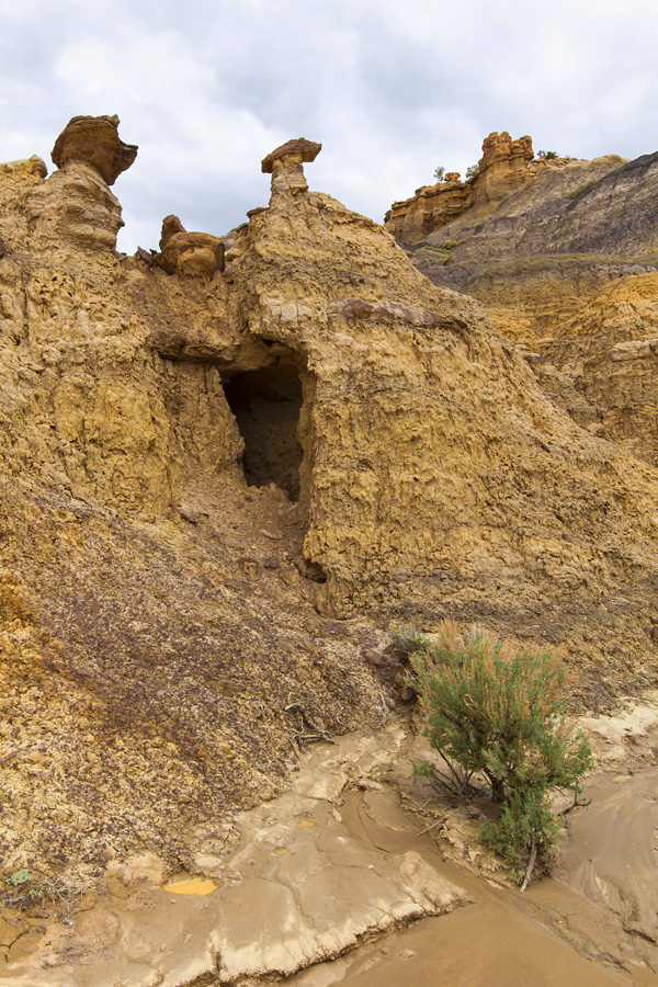
I hiked eastward into the colorfully-banded mounds of clay, capped by red sandstone boulders and the occasional flat carapace of impermeable ironstone, father to hoodoo development beneath.

After the fall
I quickly discovered that the apparently dry terrain was far from it; the normally dry mud-cracked features were now slick, wet mud-cracked features, limiting my travel options to the very bottom levels of the drainage. (An early attempt to work my way just a few steps up the side of one mound quickly met with a slip-and-fall worthy of a feeble octogenarian.)

Outflow
Under these conditions, even the slightest tilt to the surface led to sliding backward progress. I soon learned which colorations of strata made for the most serious slipping concerns (the darker ones, in general), and took care to plant feet firmly when crossing those areas.

The land beyond
Conversely and counterintuitively, the very waterlogged-appearing beds of the drainage channels ended up being some of the easiest and least-muddy areas to navigate. It never fails to amaze me how little we can understand about a terrain without actually getting out into it.

Mesa de Cuba badlands
I was pleased to have had the chance to get out and walk among the badlands, which after all had been the object of my trip from the planning stages. I made a wide loop around the basin following the edge of the erosion features before circling back to the road and my waiting vehicle. I glimpsed enough of the higher elevations of the interior to convince me that a return trip under more favorable (dry) conditions would be worthwhile.

Bits and chunks of fossil wood
Next time, for sure.

Badlands: Mesa de Cuba

Gathering clouds
Cavity

Approaching storm
Mesa de Cuba from both sides now, part 1: the east

Trailhead signage
After a day spent road-tripping in the rain (and snow) of NW New Mexico, I was more than ready to get out and stretch my legs on a trail – regardless of how wet and muddy it might be. The problem was that the approaches to the various badlands destinations on my itinerary involved unimproved dirt roads – roads now turned to perhaps impassable mud by the prior day’s heavy rains.
Not inconsiderable was my other concern: more rain in the forecast for today. Finding oneself a dozen miles out on a clay-surfaced road after a rainstorm would be tantamount to putting in for a multi-day unscheduled layover beyond the reach of civilization (not to mention one’s motel room). I didn’t have those days to spare – although I always carry water and rations enough to cover such an eventuality, just in case.

Morning dew on muddy trail
With this in mind, it seemed providential that I’d engaged in a conversation Sunday evening with Herman, the desk clerk taking the weekend shift at the Frontier Motel. When I went into the office to get hold of more coffee for the in-room machine, he happened to be reading a locally-printed news weekly featuring an article about the new trail system recently opened for foot travel. Called the Fisher Community Trail, the trailhead for this short (1.8 miles round trip) excursion was actually located on the edge of town, so no off-road travel would be required – and I’d get the chance to ascend to the top of Mesa de Cuba, whose prominent cliffs served as the distinctive western border of the village.

Reach for the sky
(I was already familiar with Mesa de Cuba—by name, anyway—because one of the badlands on my agenda sprang from an area on the other side of the same north-south trending uplift. More about which in my next post.)

Approach: Mesa de Cuba
And so it was that I pulled into the (muddy) parking area off Cubita Rd., laced up my (soon to be muddy) boots and took off “auf fuß” to see what I could see, on an improved trail that was too new to have even made it onto the interwebs. (Check for yourself if you don’t believe me.) Almost like pioneering.

Up and over
According to the trailhead signage, there’d be an opportunity to continue on past trail’s end (marked with a final cairn) to ascend to the top of the mesa. I found this to be a fairly simple matter of route finding involving only minor use of hands-on-pinon to overcome a couple of rock bands and achieve the flat-topped “summit,” providing access to literally miles of exploration above deeply intercut canyons falling off on all sides. It would take days to circumnavigate the mesa top, and judging from the section I hiked such undertaking would prove an entertaining and worthwhile endeavor.

Hello yellow.
As I’ve grown used to doing all over the southwest on almost every outdoor excursion, I soon encountered a raven swooping through the updrafts along the cliff’s edge – but what took me by total surprise was my sighting (and hearing) of a pair of honking geese there in the middle of the New Mexico canyonlands. What the… geese? Really? They settled into an alcove on the cliffside across from my vantage point and held their silence for the remainder of my stay.

Caprock crust
There’s another trail heading in the opposite direction from the trailhead that takes the hiker down into the San Jose river basin, a great place to birdwatch in the early morning or evening hours. I’ll look forward to hiking that one on another occasion.

Quintessential New Mexico: Mesa de Cuba

Downcanyon view

Somewhere here there be geese. (But you’ll have to take my word for it.)

Chockstone

Chockstone, pt. 2

Iron intrusions in sandstone

Waterpocket: Mesa de Cuba
Ruins and sacred places: village of Giusewa and San José de los Jemez church
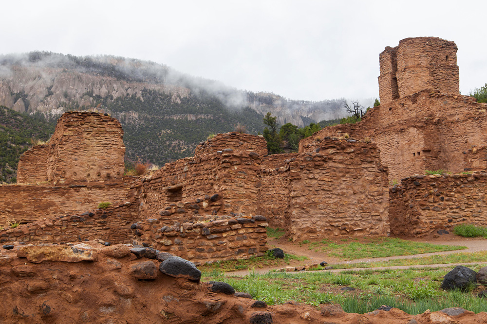
At the northern end of the small community of Jemez Springs is the Jemez Historic Site, a.k.a. Jemez State Monument. The headquarters building houses a small museum illustrating the history of the ruins on the site, which include the remains of a 16th century pueblo community (Giusewa) and a Spanish mission constructed in 1621.

Walls of stone
To those paying their first visit, the initial view of the massive mission walls and looming bell tower is bound to be a memorable one. The surrounding cliffs and ridgelines add to the drama of the setting, as did the lowering clouds on the day I was fortunate enough to be there.
Native stone
Treading quietly through these ruins, it’s impossible not to cast one’s thoughts back to their original inhabitants—both European and Native American—and wonder what life would have been like for them in this isolated canyon, with the great stone walls of the mission commanding their vision, and demanding their constant attention.

Nature vs. Man
Was it a burden or a blessing?

One world view
